Texas is drenched by heavy rains as forecasters warn that more storms
could bring dangerous floods
[July 15, 2026]
By JOSH KELETY
Heavy
downpours in South Texas washed out highways and stranded motorists
Tuesday as forecasters warned that a threat of more severe weather could
bring dangerous flooding to already drenched counties near the border
with Mexico. |
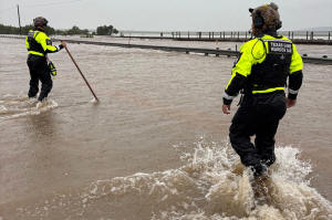
In this handout photo provided by the Texas Parks and Wildlife
Department, game wardens walk through high waters from heavy rains in
Uvalde County, Texas, on Tuesday, July 14, 2026. (Texas Parks and
Wildlife Department via AP) |
|
Storms dumped up to a foot of rain in some rural areas of Texas,
leading to dozens of high-water rescues across the region and
officials shutting down portions of a busy highway for hours
near Uvalde, about 80 miles (129 kilometers) west of San
Antonio. A flood watch also included Kerr County, where
catastrophic flooding last year along the Guadalupe River killed
more than 100 people.
No deaths or injuries Tuesday were immediately reported.
The National Weather Service warned that storms overnight could
dump more than a foot of additional rain to some places into
Wednesday, creating potentially catastrophic impacts from flash
flooding in areas west of San Antonio. Texas Gov. Greg Abbott
issued a disaster declaration for dozens of counties.
“Intense rain rates and compounding effects from multiple rounds
of storms will result in a dangerous flash flooding threat
through Thursday,” the National Weather Service said.
Authorities on Tuesday posted videos of a rescue crew in a boat
down flooded streets and one vehicle being swept away by
fast-moving waters. Five people were rescued by members of the
Texas Game Warden Search and Rescue Team and four were rescued
by a local game warden, said Maggie Berger, a spokesperson for
the Texas Parks and Wildlife Department.
In Uvalde, officials said there had been at least two dozen
water rescues. They opened a local event center for anyone
displaced by flooding. In Sabinal, officials were also making
plans for a shelter.
All contents © copyright 2026 Associated Press. All rights
reserved |
|
|