Israel presses ahead with West Bank operation as election approaches
[October 26, 2026]
By MELANIE LIDMAN
TEL AVIV, Israel (AP) — The Israeli military pressed ahead Sunday with a
massive military operation in the occupied West Bank that has displaced
hundreds of Palestinians and placed major restrictions on movement in
response to a gun attack last week that killed two Israeli soldiers and
wounded three others.
The operation, focused on the city of Hebron, the site of Friday's
attack, came as Israel enters the final days before a tense election,
which is largely seen as a referendum on current Prime Minister Benjamin
Netanyahu’s leadership and security policies during the past three years
of war.
In new measures, the army said that most Palestinian workers with
permits will not be allowed to enter Israeli West Bank settlements on
Sunday and Monday, and crossings into Israel will remain closed until
after Israel’s elections on Tuesday.
The military said it operated in more than 400 different locations over
the weekend and arrested 40 Palestinians it claimed were affiliated with
the Hamas or Islamic Jihad militant groups. No militant group has taken
responsibility for the attack.
Thousands of Palestinians displaced from Hebron
The Hebron municipality said the operation displaced more than 2,600
people.
The military said that troops were conducting searches in the area where
the gunmen operated, and warned residents to evacuate Deir Bahha, the
suspected gunmen’s neighborhood. After Friday’s attack, Israel’s
military said it found weapons in the gunmen’s car and that they were
likely planning to attack Israeli civilians before being stopped at the
checkpoint where the shootout erupted.

All entrances and exits to the city remained sealed, with the operation
focused in Deir Bahha and another part of the city called Al-Jalda,
according to Hebron Mayor Yousef Zuhair Al-Jabari.
“People cannot reach or enter the city, and they cannot leave it. The
blockade has affected every aspect of life,” Al-Jabari said. He added
that the blockade is forcing businesses to close and has also shuttered
a mosque.
“The army told us that this area would be closed for 12 days. Now
they’re saying 12 days, but maybe they’ll leave the area after two or
three days,” said Shadi al-Qawasmi, a Hebron resident who was displaced
with his family. “This may be because of the elections or some political
matter. No one knows except God Almighty.”

[to top of second column]
|
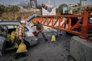
Palestinians transport bags of semolina past a military gate closed
to vehicles during an Israeli army operation in Hebron, in the
occupied West Bank, Saturday, Oct. 24, 2026, a day after a
Palestinian shooting attack in the area. (AP Photo/Mahmoud Illean)

The army declined to say how long the operation might last.
The operation forced some families to leave the city on foot. At
some military gates, people passed sacks of flour and gas canisters
through the gates, while an elderly man pushed his wife in a
wheelchair through an opening beside one of them. Another family
attempted to navigate the gate to access medical appointments.
Netanyahu vows a strong response as elections loom
Hebron municipal officials said families had been displaced from
nearly 500 apartments in Deir Bahha and surrounding neighborhoods.
Six Israelis have been killed this year in attacks in the West Bank,
which is experiencing a surge of violence. During the same period,
112 Palestinians have been killed, including the suspected gunmen,
according to the Palestinian Health Ministry.
The attack sparked outrage in Israel, with Netanyahu traveling to
the attack site and vowing to respond forcefully. On Sunday,
hundreds of mourners attended the funeral in Hod Hasharon of Sgt.
Yuval Shai Svilem, 20, one of the Israeli soldiers killed.
With the election approaching, Netanyahu is under pressure to
demonstrate a strong show of force against Palestinian attackers to
bolster his image for Israelis concerned with security.
Roughly 3 million Palestinians and 540,000 Israeli settlers live in
the West Bank, which Israel occupied in the 1967 Mideast war. Hebron
is one of its most tense cities and the only place where Jewish
settlers live in the heart of a densely populated Palestinian area
under Israeli military protection. The international community
overwhelmingly considers all Israeli settlements illegal.
___
Associated Press writer Sam Metz in Hebron, West Bank, contributed
to this report.
All contents © copyright 2026 Associated Press. All rights reserved |