Quake survivors in southwestern Japan sleep in cars in sweltering heat
as death toll rises to 34
[July 31, 2026]
By MARI YAMAGUCHI and MAYUKO ONO
TOKYO (AP) — Thousands of survivors of a powerful earthquake in
southwestern Japan spent Friday in crowded shelters or slept in cars as
they faced shortages of water, electricity and fuel and punishing summer
temperatures that stoked fears of heat-related illness.
The death toll rose to 34, the Kumamoto prefectural government said, as
rescuers raced to find those still missing after the quake triggered a
mall explosion, toppled a factory chimney and flattened homes.
Hundreds of homes remained without power as of late Friday afternoon,
down from thousands of households originally affected, as officials
worked to restore electricity. Tens of thousands more remained without
tap water.
The magnitude 7.1 earthquake hit Japan’s southern main island of Kyushu
on Tuesday. As search operations entered a fourth day, it wasn’t known
how many people remained missing and the scale of the damage to homes
across the region was still unclear.
Officials said 34 quake-related deaths had been confirmed, with one more
death still under investigation. Dozens of people were injured.
Thousands are without water and power as heat soars
About 800 households were without electricity, according to the regional
power company, while Kumamoto authorities said over 79,000 homes
remained without water. More than 9,000 people were staying in shelters,
where power sources were being added to provide air conditioning.
Fuel has also become scarce as power outages disabled gas stations and
quake damage disrupted deliveries from other regions. Many have resorted
to sleeping in their cars, but with the fuel shortage, they struggle to
keep the air conditioning running in sweltering temperatures.

Japan's weather agency and the Ministry of the Environment issued an
extreme heat alert for Kumamoto city Friday as temperatures peaked at 36
C (97 F), after stifling 35 C (95 F) heat on Thursday.
Hirokazu Sato, who lost his home in the earthquake, said he and his wife
and three children would remain in their car until they could move into
temporary housing.
“I don’t know how soon I’d be able to move in,” said Sato. “We need to
have the air conditioning on throughout the day and night, which uses up
gas.”
Kumamoto is also a major industrial hub, and there are concerns that the
quake could possibly disrupt semiconductor and auto-parts supply chains
for months to come.
Taiwan Semiconductor Manufacturing Company, a global chip giant that
operates a fab in Kumamoto, said it temporarily evacuated workers from
the facility after it experienced strong shaking from the earthquake.
The company said all personnel were safe and operations were gradually
resuming after postquake inspections found the structure was sound,
although detailed inspections and impact assessments were still
underway.
Searches continue, with the number of missing unknown
Japanese officials had described Friday afternoon as a crucial point for
rescue efforts as some experts say survival chances decline after the
first three days.
[to top of second column]
|
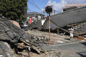
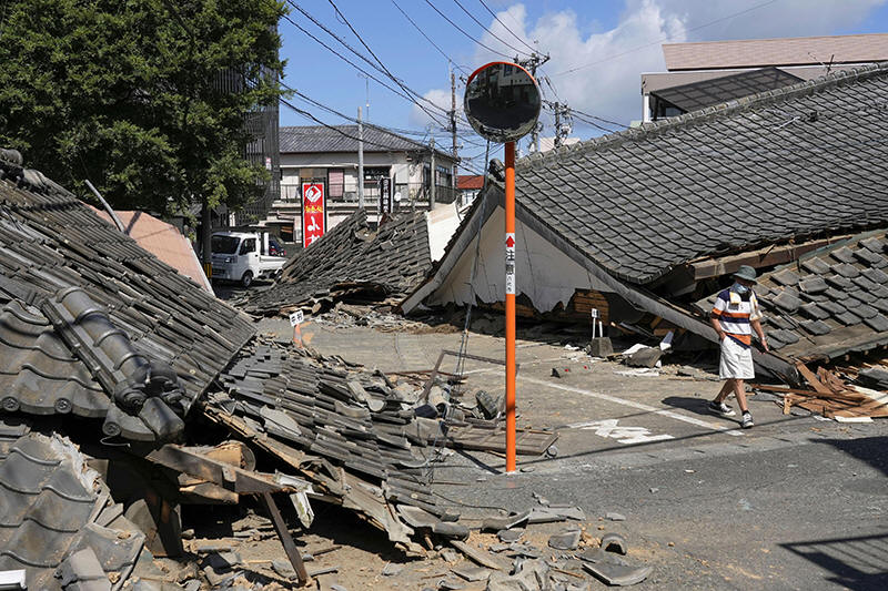
A person walks past the houses collapsed in an earthquake in
Yatsushiro, Kumamoto Prefecture, southern Japan, Friday, July 31,
2026. (Koji Harada/Kyodo News via AP)

With search dogs, rescuers continued looking for survivors across the
Kumamoto area, including at the collapsed Aeon Mall in the town of
Kashima, one of the hardest-hit sites. The complex was bustling with
thousands of people when the quake happened.
The company said about 3,000 shoppers were evacuated to a parking lot
before an explosion happened in another part of the mall, where some
staff remained working. The mall’s second floor collapsed, trapping
people.
At the site, seven people were confirmed dead and 11 had been rescued,
Japanese Chief Cabinet Sec Minoru Kihara told reporters in Tokyo on
Friday. Authorities didn't say how many were still missing.
Meanwhile, a search operation had ended at a Nippon Paper Industries
factory in the Yatsushiro area where a chimney collapsed in the quake,
Kihara said. Searchers rescued 11 people there, while nine others were
confirmed dead.
Smaller-scale searches continued Friday at the sites of collapsed houses
in badly hit towns in southern Kumamoto. Authorities haven't supplied a
firm figure for how many people are missing.
Officials assess damaged homes as some bullet trains resume
In the town of Hikawa, one of the most badly damaged parts of Kumamoto,
officials said more than 800 of the town’s 4,500 homes were destroyed or
damaged. Many residents slept inside their vehicles in parks, at the
town hall parking lot or outside their homes.
Some were without water or electricity, while others were scared to
sleep indoors. Among them was Ayako Sudo, a woman in her 70s who was
sleeping in her car with her husband.
“Since it’s a wooden house, the shaking is really intense," Sudo said.
“Even when the earthquakes are small, it shakes, and it brings up this
feeling of fear. So I think I’d really prefer somewhere that feels
safe.”
Sudo slept in her car for two weeks before, after a powerful quake that
shook Kumamoto in 2016.
“It’s exhausting," she said. "We’ve been sleep-deprived in the car.”
Meanwhile, Shinkansen bullet trains resumed between Kumamoto and Fukuoka
to the north but with reduced services, according to Kyushu Railway Co.,
while those connecting cities down south to Kagoshima were still
suspended.

Local trains in quake-hit areas, mainly in southern Kumamoto, were still
suspended due to quake damage.
____
Associated Press business writer Yuri Kageyama contributed to this
report.
All contents © copyright 2026 Associated Press. All rights reserved |